Dangerous Concentrations of Methane can Lead to Climate Change Acceleration
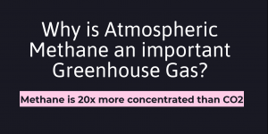
A higher concentration of Atmospheric Methane can accelerate Global Warming in dangerous levels.
Experience with Final Project
![]()
Explored different topics and data analysis to work on for our final GIS project. Our group brainstormed research topics and coordinate data downloads to have an organized mapping system- manageable for a three-person team.
Professional Development Reflection on GEOB 270 (Introduction to GIS)
My Personal Statement in line with the skills and knowledge I acquired in my introductory Geographic Information Science (GIS) course.
Final Project: Analysis of the Skytrain Extension to UBC and its Impact on Cost of Housing
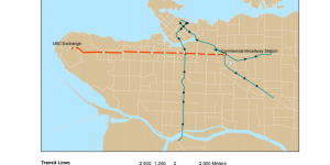
The Skytrain extension from Commercial-Broadway station to Arbutus street has completed its phase 1 evaluation and on its way to development, but the new phase 2 evaluation is considering a further extension from Arbutus street into UBC campus. My group and I discussed the possible impacts of this phase 2 extension on housing affordability and rapid transit ridership.
Lab 5: Environmental Impact Assessment (EIA)
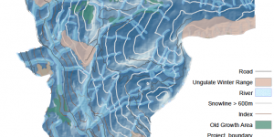
Assessing the environmental implications of the newly proposed Garibaldi Ski Resort in Squamish
Lab 4: Housing Affordability
Further practiced my skills on editing data classification and mapping aesthetically.
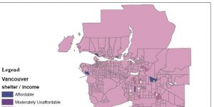
Lab 4: Cost of Housing
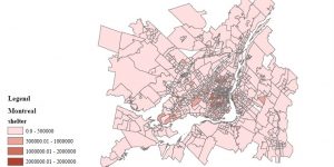
Navigated through Canadian Census Analyser site (CHASS) and downloaded cost of housing data for Vancouver and Montreal, then moving them into the file Geodatabase.
Lab 4: Data Uncertainty

What are the rules of Statistics Canada on data suppression in terms of Census Tract (CT) and Dissemination Area (DA)?
Lab 4: Quantitative Data Classification
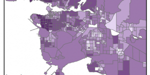
I acquainted myself with the data classification attributes. I also learned how to create a file geodatabase in ArcCatalog.
Marketing Coordinator & Photographer (2018-present)

I gained valuable soft skills during my time in Project Imagine. I coordinated, collaborated, multitasked, and until now, I am constantly learning from our executive team and volunteers.
Lab 3: Planning for Flooding/Storm Surge
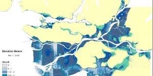
The technical aspect: This lab acquainted me to analyzing the difference between raster and vector data, and when to appropriately use these datasets when creating a map from scratch, i.e. downloading data from an open data source. I further familiarized myself with properly projecting coordinate systems, and how to troubleshoot different coordinate systems among varying layers of a dataframe